Education Links
Leaving Cert
 Maths
Maths
French
English
Chemistry
Physics
Biology
Economics
Spanish
Geography
History
Junior Cert
7. Glenasmole
 |
|
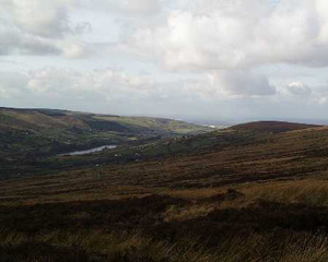
A view of Glenasmole and Dublin
from the Featherbed
|
Glenasmole is both shaped and nurtured by ice and water. We are
told that the ice sheets came in two directions - the greater flow from
the midlands plastered lime-rich sand along the sides of the valley walls
and pushed right up to the centre until depleted by climatic change it
halted leaving in its wake a great moraine which was used by the dam builders
in the 1880s to impound the river. The upper reaches of the valley received
their tills from the lime deficient local glaciers trundling downslope.
Soil fertility in the valley varies greatly from east to west and it explains
the nature and scale of farm enterprises through time. The post glacial
valley floor was U-shaped and much higher than at present but the Dodder
and its tributaries cut through the sand especially at the western end
of the glen leaving excellent sections for the geomorphologist. The river
Dodder plunges sharply from its source among the peat hags on the north
face of Kippure through a series of waterfalls and plunge pools
capturing the steep tributaries of Cot Brook and Slade Brook
in the process.
These water resources were trapped behind two dams built in the 1880s
to provide water for both the Rathmines/Rathgar townships and the many
mills which harnessed the water power. There are excellent examples of
the traditional stone mason's craft in the reservoirs and the walkways
bear witness to Victorian landscape makers. The Bohernabreena reservoir
is one of a network, Vartry and Poulaphuca are much more
extensive, which service the ever growing demands of the city below. Fortunately
our climatic regime gives 1,799mm of rainfall at the Sally Gap
and 1,172mm at the top of the valley at Glenasmole Lodge.
Almost every period of Ireland's settlement history is represented in
the glen and for the later historical period there are documentary records
to support the field evidence. The Stone Age (4,500 - 2,000 BC)
is marked by hilltop cairns on hill summits at Mountpelier, Seahan,
Seefinn and Seefinghan. Glenasmole is recognised as one
of the select hunting grounds of the Fiannaiocht and we find the names
of their leader Fionn incorporated into these placenames in for example
Seefinn which is the anglicised form of Suidhe (a seat) Finn (Fionn).
In the 1950s a gorse fire on the southern slopes of Piperstown mountain
revealed 15 prehistoric huts and cooking sites which were dated to Neolithic
(new Stone Age) and Bronze Age (2,000 BC - 400 BC) times. It may well
be that there are extensive field systems yet to be uncovered in these
south-facing slopes. In the 1980s a mechanical digger removing sand overlay
from a quarry site uncovered a Bronze Age burial cist at Piperstown
lower down the valley and a trivallate ring fort is found on the north
bank of the lower lake at Knockanteedan. There is a tradition that
one of the six royal hostels of Iron Age (400 BC - 400 AD) Ireland which
were located on the great routes to Tara was found here. This building
known in the literature as De Dearga's hostel is possibly commemorated
in the placename Bohernabreena (Bothar, road ; Brugh, hostel) translated
as the road to the hostel and locally known as the road to hospitality.
It is well to remember the importance of placenames and folklore in informing
the historic record and also to realise that Ireland was one cultural
unit in times past.
The Christian era which we have already referred to at Templeogue and Tallaght is marked in the valley by the circular graveyard site known as Killmasantan or Cill Easpug Sanctan (Cill meaning church and easpaig, a bishop) who is thought to have been a Welsh cleric. So this district was always exposed to the external influences which have had such a marked influence on Ireland. The ruins of a church are still visible and a short distance to the north is the associated holy well. This was part of Maelruan's establishment at Tallaght and when the monastic lands were incoporated into the manorial system, introduced by the Anglo-Normans, Killmasantan became a sub-manor of Tallaght. Sanctan has long since been corrupted by language change to St Anne's which is now the name of the local GAA club. The most significant external connection of the valley was with the English episcopal family of Cobbe who first arrived in Ireland in 1717 and whose founder Charles became Archbishop of Dublin in 1742. He built a magnificent mansion at Newbridge in north Dublin and managed to siphon off to his family much of the traditional church lands which included Glenasmole. The Cobbe family are then representative of the New English planters who dominated politics and the economic life of the country from c.1650 to 1900. They can be regarded as local absentees from Glenasmole but their influence is very pronounced in the valley's geography.
At the head of the valley Henry Grierson, a wealthy Dublin printer, leased a romantic site for his lodge and enclosed the wilderness. From the vantage point of the hill we can see that the settlement pattern is characterised by house clusters particularly in the poorer eastern land. Here is evidence of one of Ireland's oldest settlement forms whose origins and management have been the subject of much debate.
By the nineteenth century this type of settlement was mainly located
in the marginal lands of Ireland where as here different land quality
prevailed over relatively small spaces. They have been compared to the
pattern typical of Highland Scotland which is known as rundale and which
integrates arable, meadow, grazing and bogland into a production system
managed communally. It is seen as an egalitarian system which gave everyone
living in the cluster a share of the different land types but not an equal
share. So in the glen below farmers would have arable plots, meadow land,
grazing rights and the right to cut turf (turbary) on the bogland. Such
a system implied that the landscape in general was unenclosed. The grazing
rights on the mountain were allocated by a complicated procedure in which
the livestock unit was known as a collop and each farmers stock, especially
sheep, had to have an identifying mark. The only functioning elements
of rundale operating today are the grazing and turbary rights and the
landscape below is now enclosed in small fields. But if as part of this
trip we were to examine in detail the ownership of these we would find
a fragmented pattern which could be traced back to rundale. Although the
house clusters in Glenasmole have the characteristic siting pattern of
clusters in general they were built by the landlord in the 1840s. So it
is dangerous to classify items in the landscape by appearance alone or
from a distance on maps without fieldwork.