Education Links
Leaving Cert
 Maths
Maths
French
English
Chemistry
Physics
Biology
Economics
Spanish
Geography
History
Junior Cert
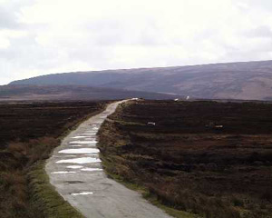
6. The Featherbed
 |
|
|
The flat bog terrain is known appropriately as the Featherbed,
blanket as distinct from the great midland raised peats, resting on impermeable
granite sand and grazed by lowland sheep and pockmarked by the wartime
peat harvesting which kept Dublin's fires lighting. Below to our west
is the valley of Glenasmole which is one of the few (Imaal
is another) Wicklow valleys opening to the west. Note how all of these
spectacular places carry the Irish word Gleann-Glencree, Glenmacnass,
Glendassan, Glendalough and Glenmalure. This well
defined physical region presents in its geographies a text of Ireland.
At the head of the valley to the east stands Kippure (2,410 feet)
capped by a communications mast, across the mountain walls of Corrig
(2,055), Ballymorefinn (1,689), Carrigeenoura and Slievebawnogue
(1,263) guard the glen from the south and westwards the Dodder escapes.