Education Links
Leaving Cert
 Maths
Maths
French
English
Chemistry
Physics
Biology
Economics
Spanish
Geography
History
Junior Cert
8. Glencree
 |
|
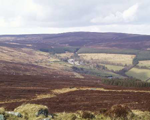
Glencree and the Reconciliation
Centre
|
On the ridges of high ground to the east the granite outcropped and
its exploitation is evident in the relict quarry sites. Georgian Dublin
was given its character by the use of this granite as cornerstones,
window lintels and stepways in city squares and as paving stones on
its streets. Eastwards towards the Irish Sea is Glencree Valley
watered by Glencree and Dargle rivers. We have only travelled a short
distance but this valley has a rather different personality than Glenasmole.
There is no evidence here of cluster settlement and the documents infer
that this was a rigidly controlled place by its Powerscourt landlords
who acquired the O'Toole patrimony in the late sixteenth century. So
there are different degrees of anglicisation which the geographer attempts
to measure. There are two significant differences here: the military
barracks at the head of the glen and the suite of great landlord houses
and demesnes beyond the roche moutonnee at Knockree. The barracks
looks towards the east and is a manifestation of Imperial power. It
is detached, it could in a sense be anywhere. The Catholic church adjacent
tells us that the soldiers belonged to the majority religion. The building
when vacated by the military became a reformatory run by the Marist
Order. It must have been a grim place for the city 'delinquents' and
the large regular fields around the complex suggest that they spent
time outdoors. Today the place is a reconciliation centre devoted to
peace not war.
At the end of the glen which faces Sugarloaf there is a cluster of a rather different kind than we noted in Glenasmole - a grouping of some of Ireland's finest landlord houses - Powerscourt, Charleville, Bushy Park and, a distance away, Kilruddery. Powerscourt was burned down accidentially but its gardens and general landscape features present a vivid contrast to the bare countryside we have travelled through. Close by is the landlord town of Enniskerry. These enterprises were not totally financed from glen land but their owners had properties and interests elsewhere in Ireland or in Britain. Wicklow was a much sought after site by military families in the eighteenth century. It was a fashionable place where the landscape, in particular the kinder eastern valleys, gave scope for ingenious landscape gardening.
 |
|
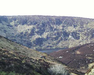
The upper Lough Bray corrie
|
Leaving Glencree behind we climb the mountain beyond the cottage where
John Millington Synge sometimes stayed on his visits to his native heath
and come upon two dramatic examples of corrie glaciation. Lough Bray
Lower and behind Lough Bray Upper are both accessible but the Upper
Lough has a long walk from the road. Corries or cirques are evidence
of local mountain glaciers which moved downhill and left behind deep
water filled depressions blocked by terminal moraines. Moraines here,
particularly that at the upper Lake, are great masses of unsorted material
plucked from the backwalls and floors of the corries. Some massive boulders
were carried downhill before the glacier lost its energy supply. Between
the armchair shaped corries is the classic arete. Beyond the Upper Lough
Bray the mountain levels out in a kind of peneplane with wide expanses
of quaking bog between Kippure and Tonduff (literally
the mountain with the black backside). In this reservoir lies the origins
of three of Ireland's famed rivers, Liffey, Dargle and
Dodder, but each makes its own independent way to the sea as
you can determine from a map. Mechanical, as distinct from hand cutting,
has seriously damaged the fragile ecosystem here by removing the protective
skin of heather and thereby led to more rapid run-off and erosion. It
is difficult to understand why such a system was allowed to operate
in this most important catchment for Dublin's water supply as the minimal
amount of peat saved could hardly justify such destruction.